
Over the years, millions of images of animals — mountain lions, black bears, deer, and many other species of interest — have been captured by camera traps on the 6,000-acre Sedgwick Ranch Reserve, part of UC Santa Barbara’s Natural Reserve System. The images are a treasure trove of information that could be immensely useful to land managers and ecologists, but most remain stored on hard drives — unsorted, uncatalogued, inaccessible, and, thus, unused.
Now a system created by UCSB computer science professors Chandra Krintz and Rich Wolski, aptly named “Where’s the Bear?” is bringing machine learning to the task of identifying and classifying animals caught on camera.
Assigning to computers a vexing task that until now was the sole purview of people saves enormous manpower — what once took fourteen days to do can now be done in three hours — and the approach has potential far beyond Sedgwick to other reserves, and beyond ecology to agriculture and even medical imaging.
Where’s the Bear works well, notes Krintz, vice chair of UCSB’s undergraduate program in computer science. “We don’t get any coyotes wrong. We don’t get any bears wrong. We get about 12-percent error on deer — there are lots of deer — and we are trying to improve on that. Now, all the ecologists are saying, ‘Count deer, count bear. Tell me if the bear is healthy. Is it the same bear, is it the same deer? How many deer are there with antlers?’”
Where’s the Bear integrates recent advances in machine-learning-based image processing to automatically classify animals in images captured by remote, motion-triggered camera traps. So far, the system has helped the Sedgwick team aggregate and analyze more than 1 million images. And because the hardware lives at Sedgwick, all the data processing is done within yards of where the data is collected.
According to Wolski, the project can inform research in endless ways, from identifying which species are present — thereby indicating, too, which are absent — to illuminating the effects of drought by revealing how animals respond when more, or less, water is available. The technology can also enhance understanding of the health of, say, the bear population, or enable more accurate deer counts to better inform the number of hunting licenses issued each year. Ranchers can use it to monitor livestock; farmers can use it to monitor their crops.
“There is nobody bridging the gap between what the reserves are doing and what scientists need to do to consume this valuable scientific resource,” Wolski says. “We’re hoping we’re providing the technology that will eventually allow researchers all over the world to have access to those images.”
Sedgwick Reserve director, Kate McCurdy, sees Where’s the Bear as a boon. “We’ve done data handoffs to researchers before, but it’s pretty unwieldy to give someone five hard drives of digital images and say, ‘Good luck finding the thing that you’re looking for,’” she says. “We need to be able to hand off a spreadsheet that’s been processed and say, ‘Here’s the data. Here are all the pictures of the deer we’ve taken over the past five years; you can crunch your own numbers and find the trends.’ To be able to develop non-invasive tools that are cheap and easy to use for land managers, property owners, ecologists, and students is huge.”
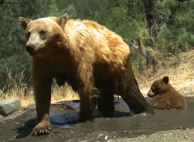
A bear and her cub as photographed by a remote camera "trap" at a Sedgwick Range Reserve watering hole.